| |
Geological Society of America Bulletin, v. 82, p.979-988, 7 figs., 8 pls., April 1971
Stratigraphy and Depositional History of Late Precambrian
Coelenterate-bearing rocks, Southeastern Newfoundland.
|
|
| << Misra 1969b |
Misra 1981 >> |
Abstract
In the map area, the Conception Group and the overlying St. Johns' Formation of the Cabot Group constitute a continuous, conformable succession of Precambrian sedimentary rocks about 8000 ft. thick, beneath an overburden of glacial drift; the base of the sequence is unexposed. Varied rocks of the Conception Group are predominantly green and purple and the St. John's shales are various shades of gray. The Conception Group is divisible into three lithologic units: Drook, Freshwater
Point, and Cape Cove Formations, in order of decreasing age. The Drook Formation is composed mainly of chert, siliceous argillite, and siltstone; the Freshwater Point Formation is sliiceous argillite with minor sandstone; and the Cape Cove Formation is composed of Cyclic beds that grade form graywacke at the bottoms through siltstone to argillite at the tops. The Cape Cove Formation contains, in its upper part, imprints of soft-bodied coelenterates represented by polyps as well as Medusae. |
| These constitute a newly described fauna, the environment of which can
be inferred from the sediments that enclose them. During late
Precambrian time, deposition of the Conception Group began in isolated
basins that subsequently joined to form a shallow marine environment.
The sea continued to deepen and became deepest during deposition of the
middle part of the Cape Cove Formation. Turbidity currents Played an important role in the deposition of the Conception Group and the St. John's Formation, and reached a maximum during deposition of the Cape Cove Formation. After a substantial thickness of the Conception Group had been deposited, the sea became shallow again, perhaps during deposition of the uppermost part of the Cape Cove Formation, and remained shallow during
post-Conception times. During deposition of the St. John's Formation, the intensity of turbidity currents decreased. Also, mild volcanism, here reported for the first time, occurred during early St. John's time.
[TOP]
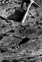
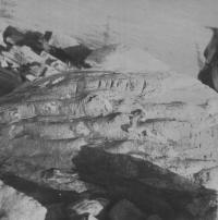
Fossils of late Precambrian organisms in the rocks of
Conception Group are the most significant aspect of geology of the Biscay
Bay-Cape Race area (Anderson and Misra, 1968; Misra, 1969a, 1969b). The fossils
are well-preserved imprints (Figs. 1, 2) of soft bodied coelenterates of
uncertain habitat. The organisms possibly were floating and colonial (Misra,
1969b). There are no direct evidences of bathymetry nor
of salinity. Therefore, a detailed study of various other aspects of the geology
such as stratification and sedimentation are necessary, in order to understand
the ecologic conditions in the Conception sea The information provided in the following pages will serve this
purpose in part, until more details
are available.
Prior to the present work, geologic studies in the
Avalon Peninsula have been conducted in the Torbay (Rose, 1952), Harbour Grace
(Hutchinson, 1953), Whitbourne (McCartney, 1967), and St, John's (Brueckner,
1971) areas. These studies, however, concern only the northern part of the
peninsula; the present study is the first in the peninsula south of the
Whitbourne map area (Fig. 3). The area is accessible by road from St. John's, 100 miles north of Biscay bay, or from the Trans-Canada
Highway via Highways 6 and 7. Within the area, there is a secondary gravel road
almost parallel to the shoreline. Inland, the area is barren and easy to
traverse in all directions. Results of mapping completed in the summer of
1967 are summarized in a geological map on a scale of 1:50,000 (Fig. 4)
[TOP]
The oldest rocks in the Avalon Peninsula are those of
the Harbour Main Group intruded by the Holyrood Granite (Rose, 1952; McCartney,
1967). These volcanic and plutonic rocks supplied most of the detritus composing
the successively overlying Conception and Cabot Groups. The latter groups are
gradationally conformable in most parts of the peninsula, except in the Torbay
map area where Rose (1952) reported a disconformity between them. In the Biscay
BayCape Race area, these groups comprise a conformable succession about 8000 ft
thick with base unexposed. The Conception Group consists of cherts, argillites,
siltstones, and graywackes and the St. John's Formation of the Cabot Group
consists of shales. The St. John's Formation outcrops on either side of the
Conception Group, at Cape Race to the east and in Biscay Bay to the west,
indicating that the map area constitutes a major anticlinorium with its axis trending northeast and passing through Freshwater Bay. This regional structure is referred to as Drook Anticlinorium.
[TOP]
The Conception Group, in the Torbay map area to the
north, was defined by Rose (1952) as a thick sequence of sedimentary rocks
overlying the Harbour Main Group and underlying the St. John's Formation of his
Cabot Group. He divided the Conception Group into the "Conception slate" and
the "Torbay slate" but did not propose a formal classification. In the
Harbour Grace area, Hutchinson (1953) recognized a formal division, the Hibbs
Hole formation, and McCartney (1967) applied this name to a correlative unit in
the Whitbourne map area. In the Biscay Bay-Cape Race area, the Conception Group
can be divided into three formations (table 1) here named in order of decreasing
age: Drook, Freshwater Point, and Cape Cove Formations. Although these rock
units are separated by gradational boundaries, each has characteristics that
distinguish it form the overlying and underlying formation.
[TOP]
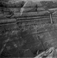
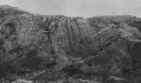
The "Drook Formation" is the name proposed for
about 2500 ft. of well-bedded, gently folded, hard siliceous siltstones and
cherts, oldest rocks of the area (Fig. 5A). The type area is Drook, 3 mi
southeast of Portugal Cove South (Fig. 4). Apart from the coastal exposures, the
formation crops out only along Drook River. many of the chert beds are
silicified siltstones varying in thickness from a fraction of an inch to 2 in.
Each bed has its characteristic color, usually a shade of green that is more
accentuated on the exposed surface. Qualitative x-ray analysis of the cherts
and argillites of the Drook /formation shows that the most common constituents
are quartz, albite, chlorite, and sericite; minor constituents are epidote,
sphene, and leucoxene. Clay minerals are absent. Calcite is found only as
concretions.
The base of the formation is not exposed, and the
contact relation between the conception Group and the underlying rocks is
unknown; the oldest beds of the formation exposed along the Drook River are
almost pure chert. The gradational upper boundary of the formation is marked by a
gradual increase in the argillaceous and arenaceous material and decrease in
silicification.
[TOP]
The name "Freshwater Point Formation" is proposed
for about 1500 ft of predominantly argillaceous beds exposed in coastal areas on
the western and eastern limbs of the Drook anticlinorium. the western coastal
section near Daly's Point is interrupted by a boulder beach, but the eastern
coastal section is complete. The formation is composed mainly of graded
siliceous argillites and siltstones, but minor amounts of fine-to medium grained
sandstones occur at the base of some graded units. The sandstones are made up of
sub-angular to sub-rounded grains of quartz, feldspar, and rock fragments set in a
matrix of chlorite, sericite, epidote, leucoxene, and sphene. The argillites are
commonly composed of quartz, albite, chlorite, and sericite. Clay minerals are
absent. The fine-grained sediments of the formation are green, the sandstones
are gray, and the weathered rocks are whitish.
Although the main rock type of the Freshwater Point
Formation is argillites, the upper-part includes graded beds composed of
sandstone at the bottom through siltstone to argillite at the top. In these
graded beds, the basal sandy part makes up less than 20 percent of the graded
units - a criterion applied to draw the upper boundary of the formation.
[TOP]
The name "Cape Cove Formation" is proposed for
about 2900 ft of graded beds that are distinguished form the Freshwater Point
and St. John's Formations based on color, cleavage, and graywacke percentage,
with emphasis on change of color from purple to gray at the upper boundary. The
type section is exposed along the northern coast of Cape Cove near Cape Race. In
addition to coastal section, the formation is also exposed along Portugal Cove
Brook and Briscal Cove River. The main part of the Cape Cove formation comprises
graded beds of graywacke and well-cleaved, green argillite. The beds are as much
as 10 ft thick and maintain a uniform thickness along strike for hundreds of
feet. The graywacke in the graded beds makes up as much as 60 percent of the
middle part of the Cape Cove Formation. The upper part of the formation includes
purple argillites and graywackes that are separated form the overlying St.
John's Formation by a transition zone of about 400ft. In addition to graded
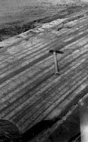
bedding, the sedimentary structures occurring in the formation include ripple
marks, sole marks (Fig. 6B) , convolute bedding, and locally small-scale
cross-stratification.
|
| The most striking petrographic feature of the
sandstones is their bimodal size distribution: abundant matrix separates large
grains and rock fragments. All rock fragments are of rock types similar to those
now exposed in the Harbour Main Group and the Holyrood plutonic series. No
metamorphic rock fragments were recognized. The composition determined by modal
analysis indicates that detrital quartz forms 22 to 38 percent of the rock. The
matrix comprises 40 to 55 percent, and is composed of chlorite, biotite, sphene,
epidote, leucoxene, pyrite, and apatite. Mineral constituents of the siltstones
and argillites are quartz, feldspar, chlorite, and sericite. Rock fragments are
absent in the siltstones and argillites, but these finer-grained rocks have a
higher proportion of opaque minerals.
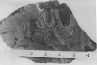
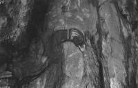
In the costal exposures near Mistaken Point, the
formation contains organic imprints that represent the fauna of the Conception
sea during late Precambrian time. Organic origin of the imprints is evident
(Misra, 1969b; Anderson and Misra, 1969) based on: (1) mode of preservation and
orientation (Fig. 1) , (2) size variation which may be ontogenic, (3) symmetry
(fig. 2B), and (4) resemblance to known Precambrian fossils. The organisms are
grouped into four categories (Misra, 1969b): spindle-shaped, round lobate,
leaf-shaped, and dendrite-like.
[TOP]
The Cabot Group defined outside the area to the north
(Rose, 1952) includes three conformable sedimentary formations which in
chronologic order are the St. John's, Signal Hill, and Black Head Formations.
Only the St. John's Formation is exposed in the map area.
The formation was named "St. John's slate" by
Jukes, 1843, "Aspidella slates" by Murrayand Howley, 1881 (Both in
McCartney, 1967), and "Momable slates" by Walcott (1899). The name "St,
John's Formation" was proposed by Rose (1952) for the sequence overlying the
Conception Group and underlying the Signal Hill Formation of his Cabot Group.
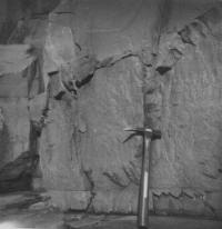
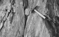
The St. John's Formation in the map area Consists of
about 1100 ft of well-cleaved (Fig. 6D) dark- to light-gray shale that overlies
coastal exposures: the first from Cape Race to Shingle Head and the second from
Biscay Bay to portugal Cove south. Apart from these coastal exposures, the
formation is found in several outcrops along back River and also along several
broks near Cape Race. the basal part of the St. John's Formation is gray,
well-cleaved, thin-bedded shale inter calated with sandstone laminae (Fig. 5D).
Sandstone beds in this part of the formation, and also in the transition zone
immediately below, commonly contain large euhedral crystals of pyrite.
Disseminated pyrite if ubiquitous. The baseal part of the formation near Shingle
Head includes a layer of volcanic tuff about 2 ft thich that is
stratigraphically only a few hundred feet above the fossil-bearing horizon in
the underlying Cape Cove Formation. This is the first report of Volcanism in the
St. John's Formation.
|
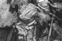
| The main part of the formation is predominantly
thin-bedded, gray shale with intercalated sandy streaks (Fig. 6D). Fracture
cleavage is very pronounced and obscures bedding in some places; but in other
place, the relation between cleavage and bedding is distinct (fig. 6D). primary
features of the formation include cross-stratification and slumping. The slump
structures (figs. 7A, 7BV, 7C and 7D) were produced by contortion of beds which
was governed, among other things, by the relative competence of the tow
lithologies in juxtaposition at the time of slumping . chert, clayey sediments,
shale, and calcareous sediments give rise to better developed slump structures
that do silty argillite and graded sandstone which are almost devoid of such
features. The rocks are medium to fine grained; microscopic examination reveals
quartz. feldspar, mica, chlorite, and pyrite. The accessory minerals are the
same as in the Conception argillite, except that pyrite is more common and
calcite more frequent. In site replacement of quartz by calcite is
indicated by parchy extinction in fine-grained sandstone and indistinguishable
boundaries between calcite and quartz grains.
[TOP]
Precambrian-Cambrian boundary in Newfoundland is
defined by Hutchinson (1962) at the first disconformity in the stratigraphic
sequence below the Callavia zone. Rocks of the Harbour Main (a predominantly
volcanic sequence), Conception, and Cabot Groups lie stratigraphically below this
boundary (Hutchinson, 1953; McCartney, 1967). However, radioactive-age
determinations (Fairbairn and other, 1966; McCartney and others, 1966) do not indicate their Precambrian age.
Nevertheless, the evidence by stratigraphic correlation is convincing, since
lower Cambrian strata "unconformably overlap" the rocks of the Conception
Group at many localities in the Avalon Peninsula (Rose, 1952). The bed rock in
the map area (Fig. 4) clearly correlates (Misra, 1969a) with the Conception
Group and the St. John's Formation of Rose (1952) although it is covered with
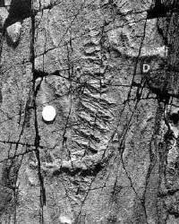
Pleistocene glacial deposits. The coelenterates reported from the Conception
Group (Misra, 1969b) are represented by polyps (Fig. 2B) as well as Medusae
(fig. 2A) . M. F. Glaessner (1968, personal commun. ) interpreted the
spindle-shaped organisms of the fauna as "a new floating colonial Hydrozoan of
the order thecata." In any case, this fauna is older than Coleoloides
and Hyolithes whcih were succeeded by Calavia fauna.
[TOP]
|
|
The sediments of the Conception Group and the St.
John's Formation were derived from a complex terrane consisting of volcanic,
igneous, and sedimentary rocks, situated to the northeast of present exposures.
The conclusions regarding the source area are drawn from rock constituents and
current directions obtained from slumping and cross stratification. The
discussion that follows indicates that the environment of deposition of the
Drook and Freshwater Point Formations was initially shallow, but became deeper
during deposition of the upper part of the Freshwater Point Formation, remained
deep during Cape cove time, and became shallow again during St. John's time . A
similar sedimentary model is suggested by McCartney (1967) in the Whitbourne map
area.
Sedimentation of the Conception Group in the Biscay
Bay-Cape Race area probably started in isolated basins bounded by volcanic rocks of the earlier Harbour Main Group. Such isolated basins are envisaged by McCartney (1967), in the case of the sedimentary
rocks that he included in the Harbour Main Group and that are strikingly similar
to those of the Conception group. These sediments assigned to the Harbour Main
Group are possibly the beginnings of the Conception Group deposition because
locally the underlying volcanic rocks and Conception Group rocks are inter-bedded
in transition zones. Subsequently, the isolated basins probably joined to form
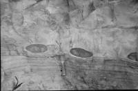
a shallow-water marine environment. Such an environment of deposition is
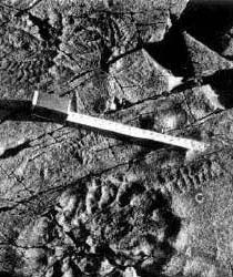
indicated for the rocks of the Drook and Freshwater Point Formations by high
content of silica in the sediments, calcareous nodules (Fig. 6A), megaripple
marks, beds exhibiting waviness (Rich, 1951), and intraformational structures
(Fig. 6C). In the Freshwater Point Formation, graded bedding, grain size,
thickness of beds, and lithology suggest that energy of the sedimentary system
had increased; the environment of deposition gradually became deeper, and by the
close of deposition of the Freshwater Point formation, the sea had become deep enough for turbidity currents of large magnitude.
Rocks of the Cape Cove Formation were probably deposited by turbidity currents. The
main arguments in favor of this are : (1) lack of evidence of tidal action, (2)
presence of sole marks (Fig. 6V), (3) large volume of graded beds, and (4) consistency in the thickness of beds and direction of supply. Flute casts
(Fig. 6B) indicate that the current hugged the bottom and was not the surface
current (Kuenen and Migliorini, 1950). Furthermore, (5) the great thickness of
some graded beds indicates a current of abnormal energy. Finally, (6) the sandstones at the base of the graded beds
contain abundant matrix which indicates that deposition of fine material has
taken place simultaneously with that of large particles. After deposition of a
substantial thickness of the Cape Cove Formation, the seaward slop upon newly
deposited detritus increased progressively. During this increase, submarine
slumping may have been initiated by agents such as wave action during heavy
storms, earthquakes, or volcanism, or by abundant supply of sediments. Slump
structures (Fig.s 7A, 7B, 7C and 7D) associated with some beds in the lower part
of the St. John's Formation indicate that deposition was still taking place on a
sloping surface and that currents which originated in shallow water probably
flowed down a slope to the deeper areas. However, siltstone laminae of the St.
John's Formation (fig. 5D) could not be the result of separate turbidity flows.
This type of lamination can be explained by traction transport that started as the
turbidity currents became more dilute and contained relatively more mud than
large particles. Small-scale cross-bedding and ripple lamination, which are in
some cases associated with flame structures, were formed by bottom traction and
not by turbulence. The presence of pyrite together with dark gray color of the shales suggest that the St. John's Formation was deposited in a reducing
environment.
[TOP]
This study was conducted as part of my graduate work at
Memorial University of Newfoundland, and was financed for the most part by W.D.
Brueckner's National Research Council (Canada) Grant No. 7882 and partly by his
Geological Survey of Canada grants. I am grateful to Professor Brueckner for
financial assistance, field supervision, and for suggesting the area. I am
thankful to E.R.W. Neale, H. Williams, and M.M. Anderson of Memorial University
and to J.A. Donaldson of Carleton University, Ottawa, for reading the paper and
making helpful suggestions. Field assistance of Donald J. Fitzpatric and Paul
thompson of Memorial University is gratefully acknowledged. Thanks are due to W.Marsh of Memorial University for help in photography.
[TOP]
-
ANDERSON, M.M,. (01972) A possible time span for the Late Precambrian of the Avalon Peninsula, Southeastern Newfoundland, in the light of world code correlation of fossils, tillites and rock units within the succession. Can. Jour. Earth Science, v. 9, pp. 1710-1726.
-
ANDERSON, M.M. and BRUECKNER, W.D., (1971) Late Precambrian Glacial Deposits in Southeastern Newfoundland- A preliminary note. Geol. Assoc, Canada Proceedings, v. 24, no. 1, pp. 95-102.
-
ANDERSON, M.M. and Misra, S.B., (1968) Fossils found in pre-Cambrian Conception Group of Southeastern Newfoundland. Nature, v. 220, no. 5168 pp. 680-681.
-
BRUECKNER, W.D., (1969) Geology of Eastern part of Avalon Peninsula, Newfoundland. Amer Assoc. Petrol. Geologistes, Mem,, no. 12, pp. 130-138.
-
McCARTNEY, W.D., (1967) Whitbourne Map-Area, Newfoundland. Geol Surv. Canada, Mem., no. 341.
-
MISRA, S.B., (1969A) Geology of Biscay Bay-Cape Race area, Avalon Peninsula, Newfoundland. Unpub. M.S. Thesis, Memorial Uni., Newfoundland, Canada, p. 139.
-
------- (1969) Late Precambrian (?) fossils from southeastern Newfoundland. Geol. Soc. America Bull,. v. 80, pp. 2133-2140.
-
------- (1971) Stratigraphy and Depositional History of Late Precambrian coelenterate-bearing rocks, Southeastern Newfoundland, Geol. Soc. America, Bull,. v. 82, pp. 979-988.
-
ROSE, E.R,. (1952) Torbay Map-Area, Newfoundland. Geol. Surv. Canada, Mem,, no. 265.
-
WALKER, T.R. , (1974) Formation of red beds in moist tropical climate: A Hypothesis. geol, Soc. America, Bull,, v. 85 pp. 633-638.
-
WILLIAMS, H,. (1964) The Appalachians in Northeastern Newfoundland- a two sided symmetrical system. Amer . Jour. Sci,. v. 262 , pp. 1137-1158.
-
WILLIAMS, H. and KING, A.F., (1976) Southern Avalon Penissula, Newfoundland: Trepassey Map-Area. Geol. Surv. Canada, paper 1A.
|
| |