
S.B.Misra, Department of Geology, Memorial University of Newfoundland, St. John�s, Newfoundland, CanadaM.S.Thesis, Memorial University., Newfoundland. Canada, p.139., 1969.Geology of Biscay Bay-Cape Race area, Avalon Peninsula,
|
||||||||||||||||||||||||||||||||||||||||||||||||||||||||||||||||||||||||||||||||||||||||||||||||||||||||||||||||||||||||||||||||||||||||||||||||||||||||||||||||||||||||||||||
| CONTENTS | |
| 1 | CHAPTER I : INTRODUCTION |
| 2 | CHAPTER II : GENERAL GEOLOGY |
| 3 | CHAPTER III : PRIMARY SEDIMENTARY STRUCTURES |
| 4 | CHAPTER IV : SECONDARY STRUCTURES |
| 5 | CHAPTER V : PRECAMBRIAN LIFE |
| 6 | CHAPTER VI : DEPOSITIONAL HISTORY OF THE AREA |
| << Chapter II | Chapter IV >> |
Primary sedimentary structures are exhibited by all formations in the map-area and include external and internal forms of bedding, organic and inorganic markings on top and under surfaces of the beds, and penecontemporaneous deformations. The distribution of primary structures in various lithologic units is controlled by lithology, conditions of deposition, and the transporting agencies that brought the sediments to the basin.
A genetic classification of primary sedimentary features is not feasible but they can be classified descriptively according to the following scheme (based on Potter and Pettijohn, 1964, p3):
| Group | Class | Sedimentary Features | |
| Bedding : external form | Class A | 1. Bedding equal or sub-equal in thickness | |
| 2. Beds laterally uniform in thickness | |||
| 3. Beds continuous | |||
| Class B | 1. Beds unequal in thickness | ||
| 2. Beds continuous | |||
| Bedding: internal organization and structure | Class A | 1. Massive | |
| Class B | 1. Laminated: | (a) Horizontal lamination | |
| (b) Cross lamination | |||
| Class C | 1. Graded | ||
| Bedding: Plane markings and irregularities | Class A | 1. On base of the beds: sole marks. | |
| Class B | 1. Within the bed: concretions, cone-in-cone, nodules etc. | ||
| Class C | 1. On top of the beds : ripple marks | ||
| Bedding: deformed by penecontemporaneous processes | Class A | ||
| Class B | 1. Founder and load structures | ||
| 1. Slump structures: folds, faults, pseudonodules, discoidal pyrite etc. |
The beds in the Drook Formation are 1 to 2 inches thick and show distinct colours (Fig. 3 - 8) which contrast sharply against one another. The thickness of beds increases gradually upward in the sequence and reaches a maximum of about 9 ft in the middle part of the Cape Cove Formation. A decrease in thickness of the beds starts after they reach this maximum and continues until the beds reduce to the thickness of a lamina (Fig. 3 - 1) or even a streak (Fig. 3 - 2) in the St. John's formation.
Most of the beds are laterally uniform in thickness and are continuous throughout the exposures which in some cases stretch as far as 500 ft. In other words, most of the beds in the map area belong to the class A of the group but some, especially those deposited during increasing or decreasing intensity of turbidity currents, belong to the Class B.
The lower and upper contacts of the beds and laminae, either graded (Fig. 3 - 7) or ungraded (Fig. 3 - 8), are generally sharp, though locally marked with irregularities, especially on the under surfaces of the beds in the Cape Cove Formation. A structure caused by disruption of a sand layer is locally seen in the sandstone beds in the Freshwater Point Formation (Fig. 3 - 4).
Rocks of the Drook Formation (Fig. 2 - 2) and of the Freshwater Point Formation, in some exposures, exhibit a massive appearance. However, a closer view of the rocks reveals that they are characterized by bedding planes, either as colour bands or as graded units. Some of the argillites in the thin section show a poorly developed alignment of flaky minerals almost parallel to the bedding planes except where they are parallel to the foreset part of the cross stratification. However, it is difficult to confirm their primary nature as most of the rocks are highly altered.
Horizontal lamination is exhibited by most rocks in the Conception Group and the St. John's Formation. Each bed or lamina represents a depositional unit laid down in most cases by turbidity currents, and manifests itself by the colour, grain size, and/or bedding plane markings.
Some of the shales and siltstones of the St. John's Formation in thin section exhibit horizontal lamination demonstrated by arrangement of minerals, with heavy minerals arranged in a row (Fig. 3 - 9) along the bottom of the laminae which are locally deformed by the weight of overlying sediments (fig. 3 - 10). The internal organization of silty shales in the St. John's Formation is well defined but in argillites of the Conception Group it is indistinct.
Cross bedding occurs as small-scale cross stratified units in the St. John's Formation and also in the underlying transition zone between the Conception and Cabot Groups. Cross stratification found in these rocks is believed to have been formed by traction currents when the turbidity currents had become weak. However, in the outcrops of the transition zone, cross bedded units alternate with shales and graded units, suggesting that turbidity currents were still in operation.
Most common types of cross stratification are solitary sets and co-sets (Allen, 1963) forming current ripple lamination in some instances. An important aspect of the cross stratification in this area is the thickness of individual sets (fig. 3 - 5) and co-sets (Fig. 3 - 6) which are hardly more than 5 cm. thick.
The angle of inclination of foreset beds varies from 20 - 35 degrees in most cases. Measurements of dip direction of foreset laminae in the two coastal exposures of the St. John's Formation, along eastern coast of Biscay Bay and near Cripple Rock Point, indicate that the structures were formed by a north to south current system. Scattered measurements from the entire area suggest that such an orientation is general.
Ten readings of current direction from cross bedding in the St. John's Formation are plotted on a palaeocurrent map (Plate 3 - 1) without correction of the tilt of the beds. The tilt, however, is low and the general direction of movement from the cross stratification is in agreement with directions obtained from sole marking and slumping.
Graded bedding is portrayed in all the three exposures of the Cape Cove Formation (Plates 2 - 1, 2 - 2, 2 - 3) but is best developed in the outcrops near Briscal Cove river. It occurs also in some horizons of the Freshwater Point Formation. Graded bedding was caused by settling of suspended sediments which settled in accordance with dimensions, specific gravities, and shapes. Settling of the sediments must have taken place during the interval between two consecutive turbidity currents.
Grading in the sediments is evident by a colour change from light grey to green or purple, which reflects a change in grain size. Graded beds in the turbidite sequence of the Cape Cove Formation vary in thickness from 3 to 9 ft. in most places and consist of greywackes at the bottom grading upward through siltstone into argillites. The finer upper part of each graded bed ends abruptly against the coarse base of the next overlying layer (Fig. 3 - 7).
Although graded bedding and cross bedding are mutually exclusive, there are some beds in the basal part of the St. John's Formation near Portugal Cove bridge that exhibit graded bedding in the lower part and small scale cross bedding with convolute bedding in the upper part.
Sole marks are restricted to the greywackes of the Cape Cove Formation. They include flute casts (Fig. 3-11), load casts, and groove casts (prod marks) which are mutually exclusive in this area. These structures are better developed in coarser greywackes than in medium or fine grained ones.
Flute casts (Fig. 3 - 12) up to 6 inches in length were seen on the soles of 3 - 9 ft thick graded beds along the coast-line between Mistaken Point and Briscal Cove River. The long axes of the flute casts are parallel to the average current direction which can be confirmed by other means such as cross stratification, slumping, and prod markings. One end of the structures ends more abruptly against the sole face, usually flaring out with a dextral bend. The end that merges gradually into the sole surface normally marks the down current direction.
Some bulbous irregularities on the under side of the greywackes were seen between Freshwater Point and Briscal Cove river. The structures, up to 1' in diameter and 3 inches in height above the sole surface, are different from flute casts in their much greater irregularity of form and absence of distinct current trends. The structures can be classified as load casts that were, presumably, formed at an early stage of deposition. The structures consist of the material which is coarser than or at least as coarse as the base of the beds in which they occur.
At Long Point, the soles of graded beds are marked with well defined grooves and ridges that taper in a S30E direction. A few fade out in the same direction. These features. although constituting grooves and ridges, are not continuous throughout the entire length of the exposed surface and are probably prod marks (Potter and Pettijohn, 1963, p.122)
The structures included under this heading have probably more than one mode of origin and some of them, especially concretionary structures, were excluded from sedimentary features by Potter and Pettijohn (1964). The structures such as cone-in-cone, stylolites, concretions etc. were, probably, formed after deposition and during consolidation of the sediments. Sandstone lenses and ellipsoidal nodules are also represented and formed during the actual process of sedimentation.
Two types of concretions occur in the rocks of the Drook Formation. One of them consists of concretionary siltstone blocks (Fig. 3 - 14) of red colour and about 2 ft. maximum diameter. The other type is ellipsoidal nodules composed of calcareous sandstone, found on both sides of Freshwater Bay.
The ellipsoidal nodules have a consistently flatter bottom side resting in a shallow depression; the curvature of the top side is distinctly convex upward (Fig. 3 - 13). Although the nodules are also slightly convex downward, most of their mass lies above the general surface of the bedding on which they lie. The colour bands in the cherts are bent below the ellipsoidal nodules suggesting a relative competence of the nodules over the cherts at the time of their formation.
Cone-in - cone structures were noted in the St. John's Formation where they consist of a nest of concentric cones arranged at right angles to the bedding surface, and ranging in height up to about 3 mm. The structures are distinct only in thin section (fig. 2 -8) and are hard to identify with the unaided eye, and as such they may be termed as micro-cones. The calcareous layers containing cone-in-cone structures are mostly less than 2 inches in thickness and are interbedded with shales in the St. John's Formation.
The structures were probably caused by pressure due to the weight of the overlying sediments. Pressure is also evidenced by bedding in some associated thin sedimentary layers. Stylolytes accompanying cone-in-come structures are also the result of this pressure.
At some places near Drook the top surfaces of the chert beds in the lower part of the Conception Group contain current formed mega ripples that measure 2 - 3 ft. from crest to crest. It is difficult to determine the direction of currents as the amplitude of ripples is low and the exposed surface has been worn down by wave action. Nevertheless, some instances indicate a southward moving current. The ripple marked surfaces in some instances are cracked along the crest of the ripple but no evidence of a diastrophic origin for the undulations is seen.
A second type of irregularity found on the top of the beds is due to impressions made by organisms living in the Conception Sea during the period of sedimentation (Fig. 2 -3). No other organic markings like trails, burrows, etc. were seen.
At several places in the map area there are within the St. John's Formation, calcareous (Fig. 3 -30) and cherty nodules formed possibly by agitation or foundering of a partly lithified thin layer. The nodules are generally sub-rounded in shape, locally stretched and elongate, and occur invariably along the strike of the beds. These deformations do not involve lateral movement of the material and are generally confined to a single layer underlain and overlain by undeformed beds. Kuenen (1959) produced pseudonodules experimentally by a process involving the foundering of sands interbedded with shales and he concluded that an earthquake might be the triggering mechanism.
A similar deformation of a thin chert layer near Drook resulted in randomly arranged, locally folded, elongate fragments (Fig. 3 -15), which are in some cases coated with a thin whitish material. The Freshwater Point argillites yield ellipsoidal and irregular fragments (Fig. 3 - 16). It seems unlikely that an unconsolidated layer could be broken into fragments, because such a layer would yield by disintegration and flowage during slumping. On the other hand if sediments were consolidated they could not be expected to fold. The sediments were, probably, in a semi-lithified state.
Slumping in the map-area is mostly confined to the St. John's Formation within which structures of various sizes have been produced as a result of contortion of the beds. The structures are governed, among other things, by the relative competence of the two lithologies in juxtaposition at the time of slumping. Cherts, clayey sediments, shales and calcareous sandstones form better developed slump structures than silty argillites and graded sandstones which are almost devoid of these features.
The most common features produced by slumping is folds of all dimensions, most asymmetrical, locally overturned, and varying in form from simple asymmetrical anticlines to recumbent and nappe- like folds (Fig. 3 - 17). In general, slump folds are most prominent and are largest immediately above the basal part of the St. John's Formation. Some of the folds near Fisher's Point have their axial planes almost vertical (Fig. 3 - 18) and affect 50' of strata.
Thin layers of calcareous clay and sandstone in the St. John's Formation near Fishers Point and Shingle Head are more intensely contorted than siltstone and shale interbeds which appear to have acted as relatively competent beds.
The layers of clayey material before they were contorted were folded such that the shaly material was sandwiched between a clay layer and the composite set was then contorted to give rise to the folds that can be seen in the vertical section at Shingle Head (Fig. 3 - 17) and in a horizontal section near Fishers Point (Fig. 3 - 18). Some parts of the calcareous sandstone layers have become thicker than the other parts (Fig. 3 - 18). These sand tumors are the result of sediment accumulation during slumping.
Intercalated sandstone laminae and sandy streaks in the St. John's Formation accentuate the slump folds (Fig.3 - 19) and faults (Fig. 3 - 20); the structures are also more obvious on weathered surfaces (Figs. 3-21, 3-22) than on fresh surfaces, probably because of small-scale differential weathering.
The axes of slump folds near Portugal Cove Point trend N40W which is at right angles to the axial trend of tectonic folds. In most other cases the axial trends of slump folds are variable. The localization of the slump folds between undisturbed strata clearly indicates their primary origin (Fig. 3-23, 3-24). Structural arrangements in the slump zones are usually complex with normal and reverse structures being present in the same bed within short distances. Some features (Fig. 3-25) bear striking resemblance to drag folds but do not conform to the tectonic deformation pattern in the area.
On the western coast of Biscay Bay, a sandstone layer of about 1' thickness has rolled in a cylindrical form (Fig. 3-26). The axis of the cylinder trends N30E which is parallel to the strike of the beds, and its axial plane is inclined opposite to the direction of dip of the beds. The cylinder was possibly formed during slump folding, although by a mechanism involving sliding and rolling of the sediments.
Slump nodules are found at several horizons in the St. John's Formation and are seen at Shingle Head, Cripple Rock Point and Fishers Point. They are generally of two types: first the nodules that are smooth on their outer surface and exhibit a concentric or spiral internal structure (Figs. 3-27, 3-28), second the nodules that have an outer rim of material which is different from the nodule itself (Fig. 3-29). The nodules were formed during slumping and are believed to be the result of rolling of the sediments.
Slumping has produced a few more features worth recording, notably hooks and sand clottings with or without a nucleus of pyrite, found in the St. John's Formation along bedding planes at almost regular intervals. The sand clottings were probably formed by slump disturbances in thin sandstone layers, resulting in the accumulation of material around a nucleus. The upper surface of such accumulations is regular but the lower surface rolled backwards, forming a hook like structure.
A similar process has resulted in the formation of discoidal pyrite with the pyrite discs placed almost equidistant along bedding planes that contain them. The discs are rimmed, especially on their upper surfaces with a coating of fibrous calcite that resembles aragonite. The pyrite was probably initially arranged in spherical patterns in the soft state, which were pressed in the form of discs by the overlying sediments. The origin of the calcite is uncertain.
In the analysis of slumping in the Biscay Bay-Cape Race area, three main aspects can be considered: first the cause of slumping, second the time, and third their use in stratigraphic correlation. The following are envisaged as some of the causes of slumping in the area.
Slump deformations in the area serve a useful purpose in correlation and are especially significant in the absence of marker horizons. A precise stratigraphic correlation of the rocks of the St. John's Formation exposed near Shingle head and those at Fishers Point is feasible on the basis of slump structures included in them (Figs. 3-17, 3-18). The slump zones at both places measure a thickness of about 50' and the type of lithology and nature of slump folds is distinctive.
| Fig. 3-1 | 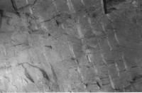 |
Laminated shales and sandstones in the St. John's Formation. Thin, light coloured layers show cross bedding which is not very distinct in the photograph. |
| Fig. 3-2 | 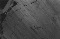 |
Photograph showing St. John's shales with intercalated (white) sandy streaks. |
| Fig. 3-3 | 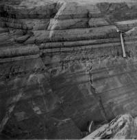 |
Photograph showing siliceous argillites (dark) with interbedded sandstones (light) in the Freshwater Point Formation. The irregular thin sandstone layer (as shown by the arrow) is possibly the result of load -casting. The rocks, also exhibit differential weathering with the argillites forming ridges and the sandstones forming the grooves. |
| Fig. 3-4 | 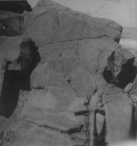 |
Photograph of the structure formed by disruption (pull apart) of a sandstone layer (light coloured) and sinking of argillites (grey in photograph) in the space between two broken parts of the layer. |
| Fig. 3-5 | 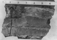 |
Single cross stratified unit underlain and overlain by shales in the basal part of the St. John's Formation. |
| Fig 3-6 | 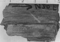 |
Photograph showing cross stratified double set (coset) in the sandstone laminae in the St. John's Formation. |
| Fig. 3-7 | 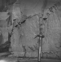 |
Photograph showing sharp contact between two graded units in the Cape Cove Formation. |
| Fig. 3-8 | 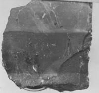 |
Detail of bedding in the Drook cherts. |
| Fig. 3-9 | 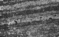 |
Photomicrograph showing internal organization in silty shales in the St. John's Formation. Pyrite grains (dark) are arranged along the bedding planes. X32 (approx) under crossed nicols. |
| Fig. 3-10 | 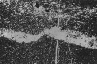 |
Photomicrograph exhibiting a siltstone layer in the St. John's Formation deformed by the load of the overlying sediments. Pyrite grains (dark in photograph) are seen in the siltstone as well as in the shale. X32 (approx.) under crossed nicols. |
| Fig. 3-11 | 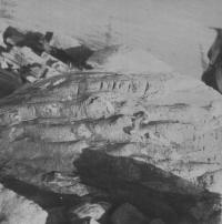 |
Sole marks on the under surface of a graded bed in the Cape Cove Formation |
| Fig. 3-12 | 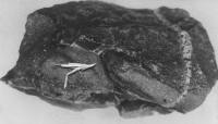 |
Flute casts in the greywackes of the Cape Cove Formation |
| Fig. 3-13 | 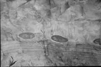 |
Ellipsoidal calcareous sandstone nodules in banded cherts of the Drook Formation. The greater part of each nodule lies above the general surface of the underlying bed. |
| Fig. 3-14 | 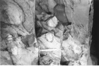 |
Photograph showing concretionary blocks of red siltstone found in the Drook cherts near Drook Point |
| Fig. 3-15 | 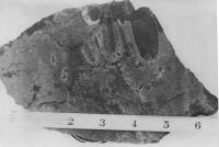 |
Elongate fragments of chert produced as a result of foundering (thixotropic deformation) in the Drook Formation. Some fragments are bent and rimmed with silty material (whitish in the photograph). |
| Fig. 3-16 | 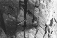 |
Photograph exhibiting fragments produced as result of foundering in the siliceous argillites of the Freshwater Point Formation. |
| Fig. 3-17 | 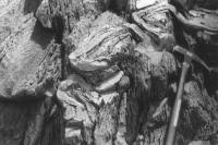 |
Recumbent and overturned slump folding in the St. John's formation near Shingle Head. |
| Fig. 3-18 | 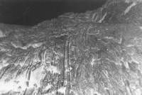 |
Photograph exhibiting slump folds near Fishers Point. Axes of the slump folds are almost vertical and sand tumors (left bottom) are formed due to accumulation of sediments during slumping. |
| Fig. 3-19 | 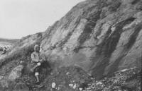 |
Slump folding in the St. John's Formation near Cape Race. Folding is emphasized by sandy streaks found in the formation. |
| Fig. 3-20 | 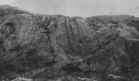 |
Slump folding and faulting in the St. John's Formation near Cripple Cove. The hammer is placed on the plane of the slump fault. |
| Fig. 3-21 | 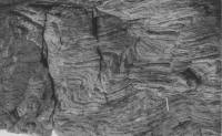 |
Slump folding as seen on the weathered surface of shale beds in the St. John's Formation near Cape Race. The structures are less apparent on the fresh surface of the shales |
| Fig. 3-22 | 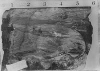 |
Small-scale slump structures seen on the weathered surface of the shales in the St. John's Formation. The structures include slump folds and faults. |
| Fig. 3-23 |  |
Small-scale slump structures in calcareous sandstones of the St. John's formation. |
| Fig. 3-24 |  |
Large scale recumbent slump folds in the St.John's Formation, Biscay Bay. Note undisturbed beds above and below the folded horizon. |
| Fig. 3-25 |  |
Photograph showing slump fold in the St. John's Formation near Fishers Point. The structure resembles a major drag fold but improperly oriented for tectonic origin. |
| Fig. 3-26 | 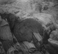 |
Photograph exhibiting a vertical cross section of a slump cylinder in the St. John's Formation, Biscay Bay. Note the relation between dip of the beds, inclination of the cylinder, and the cleavage. |
| Fig. 3-27 | 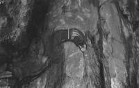 |
Photograph of a pseudo-nodule in the St. John's Formation at Fishers Point, showing concentric structure produced by slumping. The nodule is found in the vicinity of the clayey beds (Fig. 3-18) |
| Fig. 3-28 | 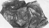 |
Internal structure of as pseudo-nodule of shale in the St. John's Formation near Cripple Cove. The nodule was tightly sitting in a surrounded hole as the material from the peripheral part of the nodule was washed out. |
| Fig. 3-29 | 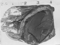 |
Photograph showing a nodule of shale that is in the St. John's Formation, shingle Head, rimmed with a thin clayey layer. |
| Fig. 3-30 | 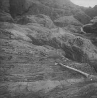 |
Photograph shows numerous nodules (dark spots in the left part of the photograph) formed as a result of shattering of a thin calcareous layer in the St. John's Formation near Portugal Cove Point |
| << Chapter II | Chapter IV >> |