
S.B.Misra, Department of Geology, Memorial University of Newfoundland, St. John�s, Newfoundland, CanadaM.S.Thesis, Memorial University., Newfoundland. Canada, p.139., 1969.Geology of Biscay Bay-Cape Race area, Avalon Peninsula,
|
|||||||||||||||||||||||||||||||||||||||||||||||||||
| CONTENTS | |
| 1 | CHAPTER I : INTRODUCTION |
| 2 | CHAPTER II : GENERAL GEOLOGY |
| 3 | CHAPTER III : PRIMARY SEDIMENTARY STRUCTURES |
| 4 | CHAPTER IV : SECONDARY STRUCTURES |
| 5 | CHAPTER V : PRECAMBRIAN LIFE |
| 6 | CHAPTER VI : DEPOSITIONAL HISTORY OF THE AREA |
| << Chapter III | Chapter V >> |
CHAPTER IVSecondary Structures |
|
The bed rock of the area comprises a distinctly layered sequence of sedimentary rocks in which top and bottom determinations can be made on the basis of graded bedding, cross stratification, and ripple marks etc. The rocks maintain a remarkably uniform northeasterly strike for several miles but swing to the northwest in the western part of the area. This setting of the rocks and the change in strike indicates that the regional structure closes beneath the water in Portugal Cove.
Most of the structures in the area may have been the result of folding and it is possible that the map-area belongs to the eastern part of a two sided Appalachian system (Williams, 1964). Most structures are related in origin and the structural pattern in the Conception Group and the St. John's Formation is the same. closely spaced fracture cleavage constitutes axial plane cleavage which developed during folding. Some of the faults are sub-parallel to the axial planes to folds; a common origin of these faults and folds is, therefore suggested. However, some faults which cut folded rocks are younger than the folds.
Although outcrops along the coast-line are almost continuous, exposures inland are sparse except along a few stream courses where the overburden has been removed and the bed rock exposed. This scarcity of outcrops and marker horizons greatly hinders the tracing of structural features inland. The geological maps accompanying the dissertation are designed to show a general distribution and relationships of rock types in the area. Most structural features are extrapolated from the coast-line inland, and the structural sections that might be constructed from the data now available would be of limited value.
Folds are unevenly distributed throughout the area with intervening parts unfolded or gently warped. Most of them are parallel or concentric with individual beds showing a uniform thickness. The axial planes of the folds are essentially vertical and the plunge angles are low.
The type of folds that occurs within a particular sequence of rocks depends to considerable extent on the cohesiveness, competence, and thickness of the successive layers (Whitten, 1966, p. 133). Thus the hard siliceous argillites of the Drook and Freshwater Point Formations are characterized by northeast trending broad open folds whereas the younger part of the sequence is tightly folded.
The most prominent of all the minor folds is the Drook anticline which occupies the core of the anticlinorium and exposes an almost complete section of the Drook Formation along both sides of Freshwater Bay. The anticline plunges southeast at about 20 degrees and trends along the western side of the bay at Drook. The attitude of the axial plane is not directly measurable but structural considerations suggest that the plane is almost vertical; however it is possible that the plane is inclined eastwards. Unfortunately the crestal part of the fold has been eroded away and now forms a valley so that it is not possible to decide, from the meager evidence available, which is the correct explanation.
In the rocks of the Cape Cove Formation near Pond Point, the folds include an anticline and a syncline (Fig. 4-2)with the axis of both running N55E and plunging 40 degrees to the SW. The limbs of the folds are inclined at angles of 65 - 70 degrees and comprise a thickness of about 500 ft. Where the deformed rocks of the axial zone are exposed at the shoreline, it is irregular and steep.
An anticline-syncline pair and other smaller folds are exposed in the rocks of the St. John's Formation near Big John's Point. The fold axes trend northeast with the limbs inclined at 25 - 30 degrees. At several localities along the coast, slickensides are preserved on calcite films or calcite layers between the bedding surfaces. They are mainly at right angles to the fold axes although some slickensides lie approximately perpendicular to this direction, indicating movement along the axes.
The folds near Long Beach are different from those in the other parts of the area in having a high angle double plunge within a short distance of 800 yards and also in having wide open tension joints in the crestal parts of the folds. The folds near Mistaken Point do not show a distinct double plunge and the beds spread like a pack of cards. Some of the folds along the Drook between Mistaken Point and Long Beach are monoclinal in shape while others are asymmetrical with the northern limb steeper than the southern one (Fig. 4 -3).
The rocks of the Cape Cove Formation along Briscal Cove River are folded into a series of parallel synclines and anticlines with their axes cutting obliquely across the river; the axes of these folds are almost horizontal and run in a northeasterly direction. On a small thickness of the beds (about 100 to 200 ft.) is affected by the folding. Several other folds having the same general character are found along the coast-line between Mistaken Point and Freshwater Point.
Many smaller folds occur along the coast-line of Portugal Cove and Biscay Bay. Near Daly's Point on the coast of Portugal Cove, the hard siliceous argillites and siltstone of the Freshwater Point Formation are thrown in series of parallel broad open folds trending N55E and plunging SW. The folds in the rocks of the St. John's Formation along the coast of Biscay Bay are relatively tighter folds and range in trend from north-northeast to north-northwest, though plunge of the folds remains in the same general direction.
Faults generally parallel fold axes and deformation along the fault planes is regarded as an integral part of flexural slip folding process. Such faults have caused a vertical or an almost vertical movement in the limbs of the folds. The distinct layering of the sedimentary rocks has facilitated internal slip during folding and favoured the development of faults that follow the bedding. As a result, bedding faults of unknown displacement are common.
Fault planes are exposed only in the coastal areas and are extended inland from there on the basis of indirect evidence. Fault displacements are generally unknown because of lack of marker horizons. However, the presence of a fault plane can be suspected from the presence of fault breccia, slickensides, mineralization, change in strike of bedding or cleavage, or any other feature suggestive of movement. Most of these criteria are insufficient for determining fault movements, as many of the rocks in the area are fractured without major displacement along numerous fracture planes.
In the eastern part of the area, the main faults are at Pond Point, Moorse Gulch, and Cape Race. The shore line at the points of emergence of these faults is marked by coves due to differential erosion of the broken rocks. Moors Gulch fault trending N40E and passing through the gulch is the most prominent of the three. In the case of the Cape Race fault, the beds of the associated fault blocks differ in strike but the amount of displacement is unknown; a thin layer of calcite, and calcite films along the fault plane are marked with well developed slickensides indicating a vertical movement.
Mistaken Point Fault (Fig. 4-5) is evident because of a 20 ft. thick fault breccia along its plane whose trace inland is marked by a shallow depression. This fault is evidently younger than folding as it affects the folded rocks and the cleavage. Of the three faults emerging on the coast-line between Mistaken and Freshwater Points, only the one at Freshwater Point is characteristic as it exhibits folding of one of its faulted blocks, probably, due to sliding of the down thrown side. The faults exposed on the coast-line of Portugal Cove and Biscay Bay are oriented in a northeasterly direction (Plate 2-4) and are defined in some cases by topography, presence of valleys or brooks, drag folds, and slickensides etc. Gash veins are developed only in the cherts and siliceous argillites of the conception Group.
In the map-area, the cleavage consists of closely spaced fracture planes that are penetrative on the scale of a hand specimen. The attitude of cleavage and that of the axial planes of folds is similar suggesting that the cleavage developed in response to strain in the whole sequence attendant on folding. As evident from its distribution in the various rock units, the cleavage is a function of lithology. In general, argillaceous rocks have yielded to fracture more easily as compared to sandstones and cherts.
The cleavage is mostly oblique to (Fig. 4-8) and locally parallel with the strike of the beds. The cleavage bedding intersection in most places is distinct and plunges gently in a southward direction. Where shales and sandstones are in juxtaposition, the cleavage planes are deflected as they pass from one into the other (Fig. 4-9).
In some places along the eastern coast of Biscay Bay in the St. John's Formation, a second fracture cleavage transects the main set of cleavage. Only a few instances of this latter fracture cleavage were observed and these were insufficient for determining whether it is also related to folding. Two sets of fracture cleavage in a few cases, and cleavage and jointing in other cases, break the shales in rhombohedra pieces.
In the map-area, joint concentration in various rock types appears to be controlled by the thickness of bedding and the type of lithology. Joint density in cherts of the Drook Formation is higher than in argillites and shales of the Cape Cove and the St. John's Formations. The argillites, it seems, reacted to strain by developing closely spaced fracture planes that constitute fracture cleavage. Joint directions are variable with several sets occurring in a single outcrop. One set is commonly vertical or close to it, and the other sets trend at various angles to the bedding and these include those which parallel the bedding as well as those at right angles to it. Joint directions in some cases are parallel with fold axes and fault planes. These joints appear, therefore, related to folding and faulting.
Joints in the rocks of the Cape Cove Formation along Briscal Cove river range in trend from N60W to N20W. The joints at Drook are wider, exposed for longer distance, and are locally filled with quartzitic and chloritic material. The joints that are filled were formed, presumably, prior to those that are open.
At. Daly's Point, two sets of joints trending N10E and N70E constitute a rhombohedral joint pattern which can also be seen at several other places in the siliceous rocks of the Conception Group. The third set in these rocks parallels the bedding planes and the three sets break the rock up into rhombohedral fragments.
Fig. 4-1 Pi-diagram obtained after plotting poles of one hundred and seventy readings of dip and strike, from all over the area, on a wulf net. The contour lines from the outermost to the innermost, represent 0%, 2.5%, %%, 10% and 15% of the total number of readings. The axial line through the area of high concentration is Pai-circle and the point encircled in the southwestern quadrangle is the plunge of the regional axis of folding determined from the diagram. The other point represents the measured plunge of small-scale folds.
| Fig. 4-2 | 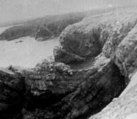 |
Photograph showing Pond Point syncline running almost parallel to the coast-line in this part of the area. |
| Fig. 4-3 | 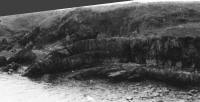 |
An asymmetrical anticline near the brook between Long Beach and Mistaken Point. |
| Fig. 4-4 | 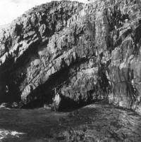 |
Photograph exhibiting an asymmetrical anticline in the hard siliceous argillites near Freshwater Point. Note also the jointing pattern in the rocks. |
| Fig. 4-5 | Photograph showing deformation of rocks in two stages: first the folding in the western part of the photograph and second the faulting in eastern part of the photograph. | |
| Fig. 4-6 | 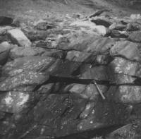 |
Jointing in the siliceous argillites of the Conception Group. |
| Fig. 4-7 | 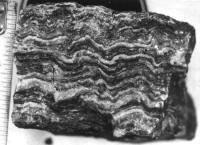 |
Cross section of a calcite layer found along the bedding planes in the St. John's formation between Shingle Head and Cripple Rock Point. Undulations represent bedding plane deformation during folding and slickensides on top and bottom surface of the layer suggesting faulting. |
| Fig. 4-8 | 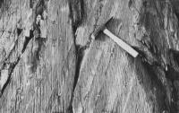 |
Fracture cleavage in the rocks of the St. John's Formation near Fishers Point (Cape Race). Not e deflection of cleavage as it passes from shales to sandstone. |
| Fig. 4-9 | 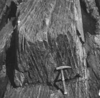 |
Photograph exhibiting cleavage in a three dimensional view. Cleavage bedding intersection is distinctly seen. |
| << Chapter III | Chapter V >> |